EN
Translate:
EN
Signed in as:
filler@godaddy.com

The District has approved the Action Plan, pending review and approval by the Chief Engineer. Throughout the five-year implementation period, the District will continue to gather stakeholder feedback.
Make your voice heard today!
The approved Action Plan is available for public review and feedback. Tap the image above to download the document.
All interested parties are encouraged to submit comments and suggestions via the online survey by clicking the button below. Your input will help address key issues in Central Kansas.

The map above shows the areas of concern identified by the District board of directors. These include the areas identified in July 2024 as well as the areas identified more recently following discussions with KGS and Balleau GW. The sections below will go into further detail for each area identified.

In 1980, the District noted declining water levels in the region upstream from the City of Larned along the Pawnee River. Accordingly, the District requested that the Chief Engineer initiate proceedings for an Intensive Groundwater Use Control Area (IGUCA). Following public hearings in late 1980, the Chief Engineer issued the Pawnee Valley IGUCA order. In the years since its establishment, this order has been amended twice by KDA–DWR at the request of the District. In 2007, the Phase I order was issued to expand the IGUCA to the upstream watershed to the west. However, this expansion has not taken place at this point. KDA-DWR maintains a website with a useful timeline and details regarding the corrective controls and copies of the Pawnee Valley IGUCA orders.
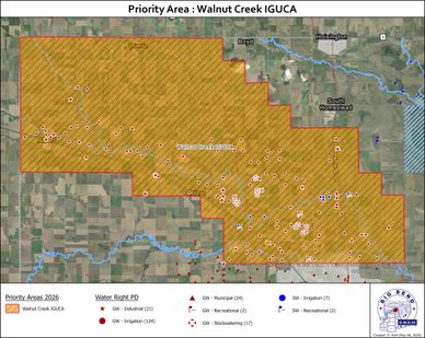
In early 1990, in response to reports from KDA–DWR, the Kansas Department of Wildlife and Parks, along with the District, requested the Chief Engineer initiate proceedings for an IGUCA in the watershed upstream of Cheyenne Bottoms Wildlife Area. There were concerns that the water withdrawals from the watershed had negatively impacted the groundwater levels to an extent that Walnut Creek was negatively affected thus limiting the supply of water to Cheyenne Bottoms. Following public input and formal public hearings throughout 1990 and 1991, the Chief Engineer established the Walnut IGUCA in portions of Rush, Ness, and Barton counties. KDA-DWR’s website has another useful timeline with details regarding the corrective controls and copies of the Walnut Creek IGUCA orders.
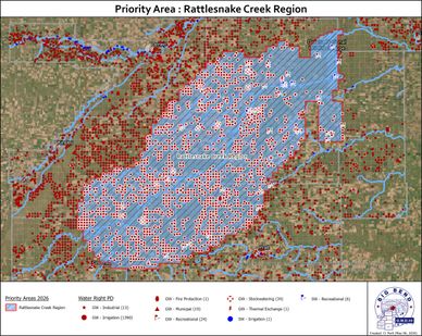
For several years, the District has been working with local, state, and federal agencies to develop a long-term sustainable program to address the water resource needs at Quivira National Wildlife Refuge (“Refuge”) in Stafford County. Since 2020 the District has contracted with Olsson to conduct a thorough evaluation of several alternatives for water management issues in the Rattlesnake Creek region. This highly anticipated work is now completed and will provide the long-term sustainable program to the region that is largely funded by USDA-NRCS funds through the Watershed Protection and Flood Prevention Program.
Meanwhile, the Kansas Department of Agriculture - Division of Water Resources has initiated a working group of stakeholder organizations to coordinate efforts to implement short-term projects for providing water use conservation and/or streamflow improvements. The District is involved in this working group effort while finalizing the larger long-term resolution for the region.
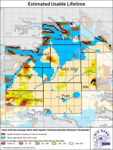
The Kansas Geological Survey has developed a methodology that can be used to estimate the usable lifetime remaining in the aquifer based on a variety of parameters. This analysis compares the recent 10-year water level trend against the amount of water available within the aquifer (saturated thickness). Then based on these two factors and assuming the water level trend would carry forward absent any management changes or climatic changes one can estimate how many years it will take before the reaching an aquifer thickness that is only able to supply up to 200 gallons per minute per well. The most recent version of this analysis includes data through 2023.
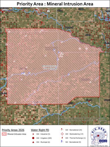
In the early 1990’s, with coordination with KGS staff, the District initiated a significant study of the water quality in the eastern half of the District. Specifically, this study identified the interaction between the deep Permian bedrock and the Great Bend Prairie aquifer in which the underlying Permian bedrock actively dissolves into the Great Bend Prairie aquifer. As a result of this study, the District identified the Mineral Intrusion area and instituted regulations to reduce the up coning of the brackish water into the Great Bend Prairie aquifer through groundwater pumping.
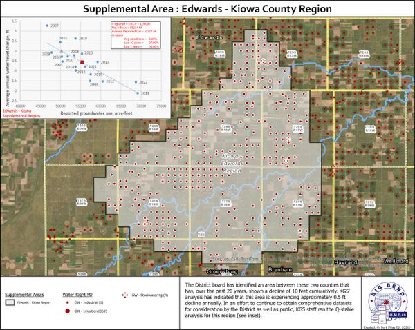
In coordination with Kansas Geological Survey (“KGS”) staff, the District board has held public meetings in Edwards and Kiowa Counties to present water level trends in this area. The District board has identified an area between these two counties that has, over the past 20 years, shown a decline of 10 feet cumulatively. KGS analysis has indicated that this area is experiencing approximately 0.5 ft decline annually. Currently, the District is watching this area to determine if this trend is growing due to escalated pumping from the region or long-term climate shifts. A major reason for not elevating this area to a priority area of concern is that approximately half of this area is overlapped by the Rattlesnake Creek Region. When the action plan for the Rattlesnake Creek Region is determined, this region’s boundary is likely to be modified. As such for the reasons above, it is premature to identify this as a Priority Area of Concern, but it is being considered by the District.
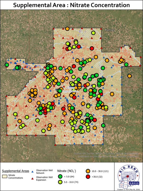
Early KGS studies have indicated elevated nitrate concentrations in the groundwater of the District (Townsend & Young, 1995). The District is currently gathering additional data points and coordinating with KDHE to better clarify the regions within the District with elevated nitrate concentrations. Until such a time that a narrower area can be identified, the District is conducting a District-wide effort to inform and encourage all water users to collect and analyze their water wells for nitrate concentrations. The District is providing water bottles for public and private use to bring water samples to the District lab for analysis. The District laboratory is not KDHE-certified, but this provides a quick and economical assessment for the public while allowing the District to collect water quality data from across the District. Once more data is collected, this can be analyzed to determine focused areas impacted by elevated nitrate concentrations. Since the District has not yet received a sufficient number of samples for analysis, effective identification of Priority Areas for nitrate concentrations is not possible.